Moelwyn hills, Eryri (Snowdonia), Gwynedd
Llyn Edno
Lake
Source image
8.2
Wildland
Full day
Time
Check
Cost
Remote
Feel
Why it's Wildland
8.2A mountain lake among crags, reached through some of the Moelwyns’ most demanding navigational country.
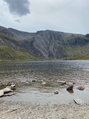
The attraction is the country around the water as much as the lake itself: crags, scattered upland lakes and paths that gradually disappear into rough ground. Llyn Edno rewards capable hillwalkers, rather than visitors looking for an easy lakeside stroll.
Remote · Wild · Peaceful
Find your way
Open mapMoelwyn hills, Eryri (Snowdonia), Gwynedd
Opening map…
The experience
Approach Llyn Edno as a hillwalking destination. The documented Bethania circuit links Llyn Llagi, Llyn yr Adar and the Ysgafell Wen ridge before reaching the lake, with an optional Moel Meirch summit diversion. Allow ample daylight and bring the skills and equipment to navigate when the path becomes indistinct.
Things to do
Pause at the lake beneath the crags
Make Llyn Edno the stopping point of a mountain walk: Walking Britain singles out its wild surroundings and solitude rather than facilities or an easy shore circuit.
Link the lakes on the Bethania circuit
Follow the documented 14.6 km outing past Llyn Llagi and Llyn yr Adar, over Ysgafell Wen and onwards to Llyn Edno. Its moderate guidebook grade comes with explicit warnings about difficult navigation and wet ground.
6 hours 40 minutes listed walking time
Add the Moel Meirch viewpoint
The walking guide describes a worthwhile summit diversion from the col beyond Llyn Edno, with an excellent view north. Assess conditions and remaining daylight before extending the walk.
Make a day of it
Quick escape · Listed walking time 4 hours 3 minutes; allow additional time for stops and navigation
The shorter sourced mountain outing
- 01
Consult the BMC’s Llyn Edno route on Komoot before setting out: it lists 12.7 km and 540 m of ascent.
- 02
Use the complete route and suitable mapping to plan the approach and return; the supplied excerpt does not provide turn-by-turn directions.
- 03
Make Llyn Edno the focus of the outing, leaving time to pause beside the lake without compromising your daylight margin.
- 04
Treat this as a substantial hillwalk, not a one-hour quick escape. The route’s Wild Swim Walks title does not establish swimming permission or safety.
Full Wildland day · 6 hours 40 minutes listed walking time, plus stops and any summit diversion
A full day among the Moelwyn lakes
- 01
Start at the small lay-by near Bethania, grid reference SH631483, using the full Walking Britain route and a suitable map.
- 02
Climb past Llwynyrhwch and the ruined barn towards the first views of Llyn Llagi beneath its crags.
- 03
Continue to Llyn yr Adar, then the Ysgafell Wen ridge, taking in the views towards Cnicht and the Dog Lakes.
- 04
Follow the documented route north to Llyn Edno and pause among the surrounding crags.
- 05
Consider the Moel Meirch summit diversion only if weather, daylight and energy allow.
- 06
Return by the described col, Afon Llynedno crossing and ladder stile towards Hafodydd Brithion. Expect intermittent paths and careful navigation.
Hidden details
The Dog Lakes below the ridge — From the second cairned Ysgafell Wen summit, marked at 669 m in the guide, look for the trio of small lakes called Llynnau ’r Cwr, or the Dog Lakes.
Human traces on the approach — The Bethania route passes a ruined barn before the first view of Llyn Llagi, then evidence of mining as it climbs beyond the lake. The supplied source gives no dates or fuller history for these remains.
When to go
· An early start with enough daylight for the complete mountain route.
The source row favours late spring to early autumn for longer days. The walking guide makes visibility and recent rainfall more important planning factors than a particular month.
Navigation can be difficult even in fine weather. Heavy rain leaves very wet ground; paths develop and fade, and the Bethania circuit crosses Afon Llynedno. Carry suitable mapping and navigation equipment and be prepared to turn back.
Worth pairing with
Llyn yr Adar
A natural companion within the same documented mountain circuit, with a different view of Cnicht to the south-west.
Llyn Llagi
The first lake seen on the Bethania approach, tucked beneath steep crags. The described path does not go to its shore.
What to look for
- 01
Crags around Llyn Edno
- 02
the three Dog Lakes below Ysgafell Wen
- 03
Cnicht seen from Llyn yr Adar
- 04
a ruined barn and mining traces on the approach above Llyn Llagi.
Best time to go
Late spring to early autumn; prioritise clear visibility and a dry spell.
Choose a clear day after relatively dry weather and start early enough for a substantial mountain walk. Walking Britain warns that the ground becomes very wet after heavy rain and navigation remains challenging even in fine conditions.
How long to spend
Full day
Perfect for
Walkers · Photographers
Practical information
Opening & access
Reached on foot through remote mountain country. Walking Britain describes a circuit from near Bethania; navigation can be difficult even in clear weather, and paths fade in places. This is not a roadside lake.
Parking
Walking Britain identifies a small lay-by at grid reference SH631483, on the minor road leaving the A498 at Bethania. Capacity and current restrictions: check before visiting.
Check before visiting
Toilets
The source row reports no toilets at the lake. Check before visiting for facilities near your chosen start.
Check before visiting
Food & drink
Check before visiting
Check before visiting
Dogs
Check before visiting
Check before visiting
Accessibility
Rough mountain terrain, fading paths and a river crossing on the documented circuit; its return includes a ladder stile. Not a step-free lakeside visit.
Cost
Check before visiting
Check before visiting
Water
Lake
Gallery
Place photographsKeep exploring
Around Llyn Edno
Within 50 km · approximate straight-line distances