Trawsfynydd, Gwynedd, Eryri National Park, North Wales
Llyn Trawsfynydd — lakeside car park and walks
Reservoir
Source image
7.2
Wildland
Half day
Time
Check
Cost
Big-sky
Feel
Why it's Wildland
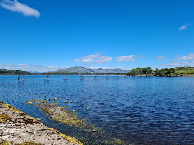
7.2A reservoir landscape where a narrow footbridge, wooded slopes and the former nuclear power station share the same view.
The car park is only the starting point. The worthwhile destination is the reservoir beyond it: a long footbridge, woodland and moorland shores, and an industrial backdrop that makes this a more complicated landscape than a conventional mountain lake.
Big-sky · Atmospheric
Find your way
Open mapTrawsfynydd, Gwynedd, Eryri National Park, North Wales
Opening map…
The experience
Make a short out-and-back visit to the footbridge and western shore, or commit to the roughly 14 km reservoir circuit. The longer walk mixes woodland and moorland with village and roadside sections: this is not an uninterrupted wilderness trail.
Things to do
Cross the narrow lake footbridge
The bridge is the opening feature of the 10Adventures route and a natural place to take in the scale of the reservoir before reaching the western shore.
Walk the full reservoir circuit
Follow roughly 14 km of roads and paths through lakeside woodland, moorland and the village. Allow for climbing on the western side and busy road sections rather than expecting an entirely flat shore path.
3–5 hours walking, depending on route and pace
Pause for birds and flowering vegetation
Use the quieter walking pauses to watch the reservoir and its margins. The route guide highlights bird diversity and wildflower displays, but supplies no reliable species list or precise flowering dates.
Make a day of it
Quick escape · Allow 1–2 hours; suggested visit length, not a measured route time
Quick escape: the footbridge and western shore
- 01
Start at the lakeside car park by Trawsfynydd and check current path notices.
- 02
Follow the published walking approach to the narrow footbridge for views across the reservoir.
- 03
If conditions and time allow, continue onto the climbing woodland path on the western side.
- 04
Turn back along the same approach rather than committing to the full circuit.
Half day · Allow 4–6 hours including stops; published walking estimates range from 3–5 hours
Half day: walk the reservoir circuit
- 01
Download a current route map before leaving the lakeside car park.
- 02
Cross the footbridge and climb through the western woodland, pausing where views open over the water.
- 03
Continue around the northern shore, with the dam and power-station landscape adding context to the walk.
- 04
Consider the café near the northern visitor centre if open.
- 05
Complete the chosen mapped circuit through Trawsfynydd, taking particular care on road sections.
Verified history
The walking guides date the creation of this man-made reservoir to 1924–1928. AllTrails describes its later use as cooling water for the nuclear power station from 1965. That industrial chapter remains part of the walking experience: the former station occupies the northern shore, while the circuit also encounters the reservoir's dam infrastructure. These are secondary-source accounts rather than an independently checked archival history.
Hidden details
The northern dam has a name — AllTrails identifies the northern, principal dam as Argae Newydd Maentwrog and notes that it is one of four dams around the reservoir. It gives the water's engineered shoreline a specific feature to look for.
The western shore is not entirely flat — The 10Adventures guide places most of its route's climbing in the western woodland after the footbridge. The reward is a changing perspective over the reservoir and surrounding Eryri landscape.
When to go
May · June · July · A daylight start with several hours available for the circuit; no particular peak viewing hour is established.
Late spring and early summer are an editorial preference for flowering vegetation and longer days. The supplied guide gives a broader February–November walking season, without exact flower-peak dates.
Check the forecast and current path conditions before walking. Allow extra time in poor weather; the circuit includes a narrow bridge, climbing paths and roadside sections.
The route
- ascent
- Conflicting published figures: AllTrails 606 ft / approximately 185 m; 10Adventures 1,247 ft / approximately 380 m. Check the chosen route.
- surface
- Mixed roads and paths, including woodland and moorland sections
- distance
- Approximately 14 km / 8.6–8.7 miles, depending on the mapped variant
- duration
- AllTrails: 3–3.5 hours; 10Adventures: 3.5–5 hours
- difficulty
- AllTrails rates its circuit moderate; 10Adventures rates its version easy. Plan for a substantial walk with climbing and road sections.
- waymarking
- Both walking guides describe good waymarking; carry a current map.
- route shape
- Loop
- start point
- Trawsfynydd lakeside car park near the village
- parking start
- AllTrails describes access from the A470 south of the village. Check current parking restrictions.
- shorter alternative
- Suggested out-and-back to the footbridge and western shore; turn around to suit time and conditions. No measured short-route distance is supplied.
- Narrow reservoir footbridge
- Western woodland and elevated views
- Northern dam
- Former power-station landscape
Worth pairing with
Northern lakeside café
The route guide places a café by the visitor centre on the northern shore, making it a useful circuit stop rather than a separate attraction. Its name, hours and current operation need checking.
Trawsfynydd village refreshment stop
AllTrails describes a village pub on the circuit. Consider it as a finish or walking break, subject to checking the venue and opening hours.
What to look for
- 01
The narrow footbridge over the water
- 02
views opening as the western path climbs through woodland
- 03
the northern dam
- 04
and the former power station that explains the reservoir's later industrial role.
The story
Industry
Best time to go
Spring and summer for wildflowers and longer walking days; the route guide suggests February–November.
Choose a clear spring or summer day for the western-side views and flowering vegetation. Start early enough to leave several hours for the full circuit and pauses; there is no sourced evidence for a particular quiet hour.
How long to spend
Half day
Perfect for
Walkers · Photographers · Wildlife lovers
Practical information
Opening & access
Published walking guides identify this lakeside car park as a starting point for the reservoir circuit. Approach from the A470 south of the village. Check current access and signage before setting out.
Check before visiting
Parking
Walking guides place the start at the lakeside car park, reached from the A470 south of Trawsfynydd. Charges and opening restrictions at this specific car park: Check before visiting.
Check before visiting
Toilets
The imported record gives conflicting toilet information. Reviews mention toilets elsewhere at the lake but do not establish facilities at this car park. Check before visiting.
Check before visiting
Food & drink
A walking guide identifies a café by the visitor centre on the northern part of the circuit and a pub in the village. Neither should be assumed to be at this car park. Check before visiting.
Check before visiting
Dogs
Both walking guides allow dogs; keep them on a lead around livestock and road sections.
Accessibility
The circuit includes a narrow footbridge, woodland climbing and a mixture of roads and paths. Step-free access, accessible parking and toilet provision are not established. Check before visiting.
Check before visiting
Cost
Check before visiting
Check before visiting
Water
Reservoir
Gallery
Place photographsKeep exploring
Around Llyn Trawsfynydd — lakeside car park and walks
Within 50 km · approximate straight-line distances
 Source image7.4
Tanygrisiau Reservoir
Tanygrisiau, near Blaenau Ffestiniog, Gwynedd, North Wales
9.8 km away
Llyn Cwm-mynach
Cwm Mynach, near Bontddu and Dolgellau, Gwynedd, North Wales
11.3 km away
Llyn Dinas and Llyndy Isaf Circular
Nant Gwynant, near Beddgelert, Gwynedd
17.1 km away