Eryri (Snowdonia), North Wales
Y Lliwedd
Viewpoint
Source image
6.5
Wildland
Full day
Time
Check
Cost
Dramatic
Feel
Why it's Wildland
6.5A rugged peak on the Snowdon Horseshoe, Y Lliwedd offers a high mountain ridge experience above Llyn Llydaw and Glaslyn. Reaching it on the sourced circular route involves a demanding walk and exposed, scrambling terrain.
Y Lliwedd stands out for its dramatic ridge and mountain setting, but this is a serious mountain outing rather than an easy viewpoint walk. The sourced route warns that the ridge requires sure-footedness and a good head for heights, and should be avoided in bad weather.
Dramatic · Wild · Remote
Find your way
Open mapEryri (Snowdonia), North Wales
Opening map…
The experience
The supplied evidence supports a challenging circular mountain route from Pen-y-Pass via Yr Wyddfa, the Watkin Path and Y Lliwedd ridge. It is not a short or casual outing. Allow a full day, use current route and weather information, and do not attempt the ridge in poor conditions.
Things to do
Walk the Y Lliwedd ridge
Include the ridge as part of a demanding mountain outing. The route source warns that it requires sure-footedness, a good head for heights and scrambling.
Take in the mountain lakes from above
The supplied route description passes Llyn Llydaw and Glaslyn and describes views along the route. Visibility will depend on conditions.
Make a day of it
Quick escape · Not established by supplied sources
A short look at the mountain
- 01
The supplied sources do not establish a short, straightforward visit to Y Lliwedd.
- 02
Do not treat the exposed ridge as a quick excursion; check current route and mountain conditions before planning.
Verified history
The supplied route source says the Miners’ Track was built in the 19th century to serve the Britannia Copper Mines, which it says were abandoned in 1917. This is history of the approach route, not a verified account of Y Lliwedd itself.
When to go
· No specific time of day is established by the supplied sources. Prioritise suitable mountain weather and visibility.
The supplied sources provide no dependable seasonal recommendation. Mountain weather and visibility are important, and the route source advises avoiding the ridge in bad conditions.
Conditions can make the exposed ridge unsafe. The AllTrails route description advises avoiding it in bad weather; check an up-to-date mountain forecast and route conditions before departure.
The route
- ascent
- 2,903 ft for the sourced circular route
- surface
- Mountain paths; the ridge includes scrambling terrain.
- distance
- 8.5 miles for the sourced Yr Wyddfa–Y Lliwedd circular route
- difficulty
- Hard; the Y Lliwedd ridge requires sure-footedness, a good head for heights and scrambling.
- route shape
- Loop
- start point
- Pen-y-Pass
- parking start
- Pen-y-Pass car park; limited spaces and can become extremely busy. Check current arrangements.
- Y Lliwedd ridge
- Llyn Llydaw
- Glaslyn
- Yr Wyddfa summit on the sourced circular route
- Bwlch y Saethau and Bwlch Ciliau on the described descent
What to look for
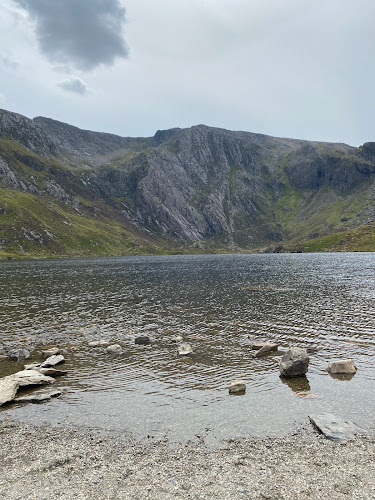
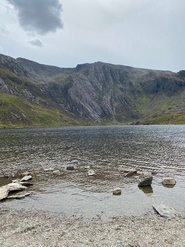
Look for the contrast between the high Y Lliwedd ridge and the lakes below, including Llyn Llydaw and Glaslyn. The supplied route description also identifies Bwlch y Saethau and Bwlch Ciliau along the descent.
The story
Mountaineering heritage is mentioned in the source row, but its claim about Everest training is not corroborated by the supplied research sources.
Best time to go
No specific best season is established by the supplied sources. Check mountain conditions before visiting.
No reliable month-specific recommendation is available from the supplied sources. Choose a day with suitable mountain conditions and good visibility; avoid the ridge in bad weather.
How long to spend
Full day
Perfect for
Walkers · Photographers
Practical information
Opening & access
Mountain walking routes reach Y Lliwedd. The sourced circular route starts and finishes at Pen-y-Pass; check current conditions and access information before setting out.
Check before visiting
Parking
The sourced circular route starts at Pen-y-Pass. Its car park has limited spaces and can become extremely busy; check current parking arrangements before travel.
Check before visiting
Toilets
Check before visiting
Check before visiting
Food & drink
The AllTrails source notes a café at the Yr Wyddfa summit visitor centre, which is only open when trains are running and is weather-dependent. Check before visiting.
Check before visiting
Dogs
The source row marks Y Lliwedd as dog friendly, but route-specific rules and conditions are not supplied. Check before visiting.
Check before visiting
Accessibility
The mountain route is hard and includes steep, exposed ridge terrain and scrambling; it is not suitable for wheelchair access.
Cost
Check before visiting
Check before visiting
Water
Nearby mountain lakes include Llyn Llydaw and Glaslyn. Swimming permission is not established.
Gallery
Place photographsKeep exploring
Around Y Lliwedd
Within 50 km · approximate straight-line distances