Near Abbotsbury, Dorset DT3 4JX
Kingston Russell Stone Circle
Prehistoric
Place photograph
7.0
Wildland
Half day
Time
Free
Cost
Wild
Feel
Why it's Wildland
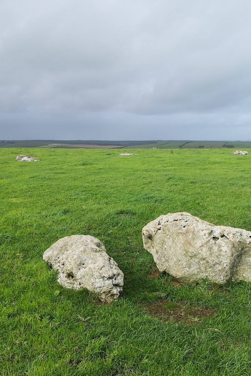
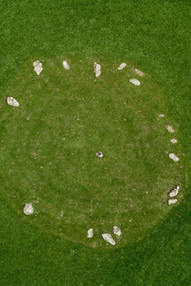
7.0Eighteen fallen stones mark a late Neolithic or early Bronze Age circle on a hilltop above Abbotsbury, with views towards the sea.
The appeal is the combination of an exposed hilltop setting and a substantial walk to a prehistoric circle of fallen stones. It is a remote, unsheltered visit rather than a roadside monument: allow for the mile-long approach, cattle-grazed land and muddy tracks.
Wild · Atmospheric · Remote
Find your way
Open mapNear Abbotsbury, Dorset DT3 4JX
Opening map…
Know this place a little better?
The experience
Walk from the limited verge parking by the cattle grid, follow the gravel track and field edge for about a mile, then spend time with the circle and its hilltop setting. The site is exposed, with no shelter; sturdy waterproof footwear is advised in wet weather.
Things to do
Walk the field-edge approach
From the gravel track beside the cattle grid, follow the field edge for approximately one mile to reach the circle. The track is used by farm vehicles and can be very muddy in wet weather.
Spend time among the fallen stones
See the 18 fallen stones of this late Neolithic or early Bronze Age circle in its exposed hilltop setting above Abbotsbury and the sea.
Extend the outing in Abbotsbury
The nearby village offers shops, places to eat and facilities. English Heritage also points visitors towards St Catherine’s Chapel and Abbotsbury Abbey remains.
Make a day of it
Quick escape · Allow time for the approximately one-mile walk each way, plus time at the circle; no visit duration is stated by the source.
Quick escape: walk to the stone circle
- 01
Use the limited verge parking before the cattle grid on the lane to Gorwell Farm; do not park beyond the cattle grid.
- 02
Take the gravel track to the right of the cattle grid and follow the field edge for approximately one mile.
- 03
Visit the stone circle and take in its hilltop position above Abbotsbury before returning by the same approach.
- 04
Keep dogs on leads across cattle-grazed land and wear sturdy waterproof footwear if conditions are wet.
Half day · Half day; exact timings are not supplied.
Make a half day of it: stones, Abbotsbury and the ridge landscape
- 01
Walk out to Kingston Russell Stone Circle and return along the approach track.
- 02
Drive to nearby Abbotsbury for its shops, food outlets and facilities.
- 03
If time and access arrangements suit, add St Catherine’s Chapel overlooking Chesil Beach or the remains of Abbotsbury Abbey.
- 04
For a further prehistoric stop, consider Winterbourne Poor Lot Barrows or The Nine Stones; check each place’s current access information before setting out.
Verified history
English Heritage identifies Kingston Russell as a late Neolithic or early Bronze Age stone circle of 18 fallen stones. The supplied source does not provide a more detailed account of its construction or use, so those details are not asserted here.
Folklore & legend
No specific local legend is established by the supplied research. Dorset National Landscape mentions myths and legends associated with the wider ancient South Dorset Ridgeway landscape, but does not detail them on the supplied page.
Hidden details
The circle is made up of fallen stones — English Heritage describes the monument as a circle of 18 fallen stones, a detail worth looking for rather than expecting an upright ring.
The approach crosses working farmland — The route follows a field edge across land grazed by cattle, and the track is used by farm vehicles. Keep dogs on leads and expect muddy conditions after wet weather.
When to go
· Daylight; English Heritage says the site is open at reasonable times during daylight hours.
No month-specific seasonal information is supplied. Drier conditions may make the farm track easier to walk; it can be very muddy in wet weather.
The site is very remote and exposed with no shelter. The track can be very muddy in wet weather; sturdy waterproof footwear is advised.
Worth pairing with
Abbotsbury
A short drive away, with shops, food outlets and facilities.
St Catherine’s Chapel
An atmospheric chapel overlooking Chesil Beach, identified by English Heritage as a nearby pairing.
Abbotsbury Abbey remains
The remains of the abbey are another nearby heritage stop suggested by English Heritage.
Winterbourne Poor Lot Barrows and The Nine Stones
English Heritage suggests these nearby prehistoric sites for extending exploration of Dorset’s prehistoric landscape; check current access before visiting.
What to look for
Look for the group of 18 fallen stones and notice how the circle occupies an exposed hilltop above Abbotsbury, with the sea in the view.
The story
Prehistoric archaeology; late Neolithic or early Bronze Age stone circle
Best time to go
Daylight visits are described by English Heritage; choose drier weather if you want to avoid the track becoming very muddy.
Visit during daylight. Drier weather is preferable because the farm track can become very muddy; there is no shelter at the site.
How long to spend
Half day
Perfect for
Walkers · History lovers · Photographers
Before you go
Address
Phone
Website
Listed hours
- Monday: Open 24 hours
- Tuesday: Open 24 hours
- Wednesday: Open 24 hours
- Thursday: Open 24 hours
- Friday: Open 24 hours
- Saturday: Open 24 hours
- Sunday: Open 24 hours
Check before visiting.
Google rating
Practical information
Opening & access
English Heritage describes the site as open at reasonable times during daylight. From the lane, access is on foot via a gravel track and field edge for approximately one mile. The route crosses land grazed by cattle; the track can be very muddy in wet weather.
Parking
Limited verge parking just before the cattle grid on the lane to Gorwell Farm. Do not park beyond the cattle grid. English Heritage gives the What3words location axed.corkscrew.scraper.
Toilets
Public toilets are available in nearby Abbotsbury, according to English Heritage.
Food & drink
Shops and places to eat are available in nearby Abbotsbury, according to English Heritage.
Dogs
Keep dogs on leads while crossing land grazed by cattle, as advised by English Heritage.
Accessibility
Access is on foot along a gravel track and field edge for approximately one mile. English Heritage flags uneven surfaces; the track can be muddy. Its source listing says the site does not have a wheelchair-accessible car park or entrance.
Cost
Free
Gallery
Place photographs
Keep exploring
Around Kingston Russell Stone Circle
Within 50 km · approximate straight-line distances