Old Scotch Road, Killington, near Sedbergh, Cumbria, LA6 2HB
Burns Beck Moss
Bog
Place photograph
7.4
Wildland
1–2 hours
Time
Donation
Cost
Peaceful
Feel
Why it's Wildland
7.4A former glacial tarn where two rarely neighbouring types of mire now share a small Cumbrian reserve.
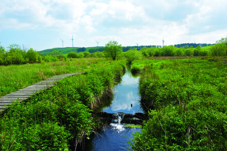
The interest here is under your feet rather than on the skyline. Rain-fed raised mire and groundwater-fed valley mire occur together unusually, giving this 15-hectare reserve a depth of ecological interest its short circuit might otherwise conceal.
Peaceful · Wild
Find your way
Open mapOld Scotch Road, Killington, near Sedbergh, Cumbria, LA6 2HB
Opening map…
Know this place a little better?
The experience
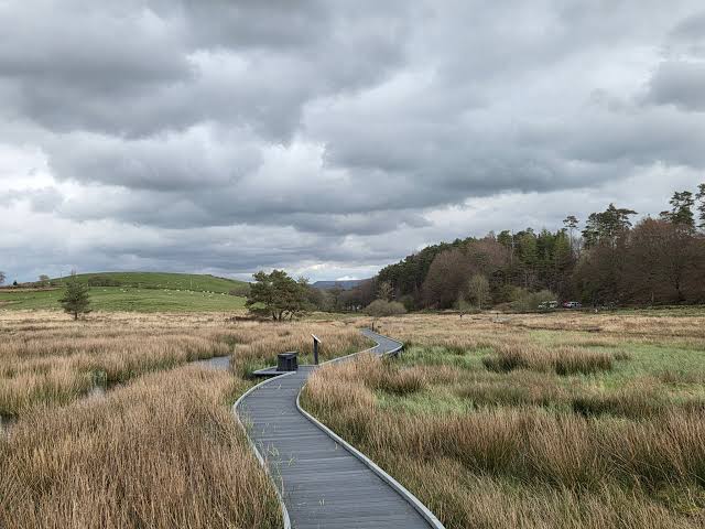
Take the available waymarked path slowly, stopping for warblers, butterflies and wetland plants rather than treating the reserve as a distance walk. The advertised circuit is only 0.9km, but access conditions need checking before you set out.
Things to do
Listen for summer warblers
Pause along the path for sedge, willow and grasshopper warblers. Curlew, meadow pipit and whinchat are also listed among the reserve's summer birds; sightings are not guaranteed.
Look closely for wetland butterflies
Watch for green hairstreak, small pearl-bordered fritillary and small heath butterflies, all highlighted by the Trust. Keep observations and photography to the path rather than stepping onto fragile wet ground.
Make a day of it
Quick escape · Allow 1–2 hours for wildlife stops; suggested visit length, not a measured walking time.
A slow look at the moss
- 01
Check the Trust's current bridge and path advice before travelling.
- 02
Park in the quarry opposite the reserve and cross Old Scotch Road to the entrance.
- 03
Follow the open, waymarked path sections, using the advertised 0.9km circuit only if confirmed passable; never bypass a closure across the bog.
- 04
Pause to watch wetland birds and, in summer, look for butterflies and flowering plants from the path.
- 05
Return by the available marked route, keeping dogs on a lead.
Verified history
Around 10,000 years ago, retreating ice left a small tarn here. Sediment and plant remains gradually filled it, allowing peat bogs to develop. Much later, Burns Beck was deepened and straightened, and drains were dug in preparation for tree planting that never happened. Visit Sedbergh dates the Trust's acquisition to 1995. Since then, work to raise water levels has helped the mires recover. This is therefore a recovering wetland, not an untouched one.
Hidden details
Two different water supplies sustain the moss — The raised mires rely entirely on rain, while the valley mires receive groundwater carrying dissolved minerals and nutrients. Their coexistence is unusual; the Trust identifies only a small number of comparable Cumbrian sites near Torver and Winster.
When to go
April · May · June · July · August
The Trust recommends April–August: wetland birds are a spring and summer draw, and many specialist wetland plants flower in summer.
Wet and uneven ground is part of the visit. Boardwalks and paths can be slippery after rain, with ditches and deep water nearby. Wear sturdy waterproof footwear and do not leave the path to get around closures.
What to look for
- 01
Look for green hairstreak, small pearl-bordered fritillary and small heath butterflies
- 02
listen for sedge and grasshopper warblers in summer. The less obvious distinction is between rainfall-fed raised mire and mineral-bearing groundwater-fed valley mire.
Best time to go
April–August for wetland birds, flowering plants and butterflies.
The Trust recommends April–August. Spring and summer bring wetland birds, with summer particularly rewarding for specialist flowering plants. Choose a calm, dry spell for easier wildlife watching, while expecting wet ground regardless.
How long to spend
1–2 hours
Perfect for
Wildlife lovers · Photographers · Solo
Practical information
Opening & access
Open all year, with access directly from the public road. The Trust describes a 0.9km waymarked circuit but flags a closed bridge and planned path replacement by spring 2025. That wording is dated: check current path conditions before relying on a complete circuit. Keep to the paths; there are ditches, deep water and extremely wet ground.
Check before visiting
Parking
Off-road parking in the quarry opposite the reserve, at grid reference SD 595 880; cross the road to the entrance at SD 595 879.
Toilets
The imported record reports no toilets. Check before visiting.
Check before visiting
Food & drink
Check before visiting
Check before visiting
Dogs
Dogs on a lead.
Accessibility
Mainly flat, but with uneven, wet sections, boardwalks and bridges. Paths can become slippery after rain. The Trust flags a bridge closure; current completion of planned path works is unconfirmed. Do not assume step-free or wheelchair-suitable access.
Cost
Donation
Water
Stream
Gallery
Place photographs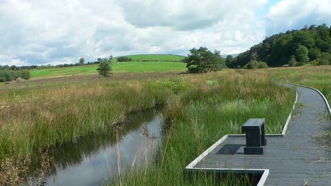
Keep exploring
Around Burns Beck Moss
Within 50 km · approximate straight-line distances
 Place photograph7.1
Fell End Nature Reserve
Slackhead Road, Hale, near Milnthorpe, Cumbria
14.0 km away
 Place photograph8.9
Gait Barrows National Nature Reserve
Between Silverdale and the Yealands, Lancashire
16.0 km away