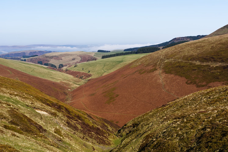
Near New Radnor, Powys, Mid Wales
Radnor Forest
Moor
Source image
7.5
Wildland
Half day
Time
Free
Cost
Wild
Feel
Why it's Wildland
7.5Despite its name, Radnor Forest is an upland landscape of open moorland, heath and scattered woodland. From its high ground, paths cross exposed plateaux and wooded slopes, with wide views across the Welsh Marches and Cambrian hills.
The name is misleading in the best way: this is not simply a forest walk, but a broad, exposed upland landscape of heath, wooded slopes, deep ravines and far-reaching views. The combination of open high ground and the dramatic Water-break-its-neck waterfall gives it a stronger sense of adventure than an ordinary woodland visit.
Wild · Secluded · Big-sky
Find your way
Open mapNear New Radnor, Powys, Mid Wales
Opening map…
The experience
Come for a walk that moves between woodland tracks and open upland. A route from New Radnor can climb towards Whimble before crossing more open ground; Water-break-its-neck is a distinctive waterfall stop. High routes are exposed, so carry suitable clothing and check conditions.
Things to do
Walk towards Whimble
The New Radnor circular route described by the local forest group climbs to nearly 2,000-foot Whimble early on, then crosses plateau and descends. Expect a strenuous initial climb and open views; check the complete route and conditions before setting out.
Visit Water-break-its-neck
See the waterfall at the end of a deep gorge. The local forest group describes it as a historic day-trip destination from the spa town of Llandrindod Wells.
Follow a historic drovers’ road
Explore a local route associated with drovers and look for the distinctive clumps of Scots pines described as waymarks. Confirm the route and access rights before following it.
Cycle local forest routes
The Friends of Radnor Forest describes cycling routes of varying distance and difficulty, with starts including Mutton Dingle, Water-break-its-neck and Fishpools. Consult a route map and confirm current access and parking before riding.
Make a day of it
Quick escape · Short visit; exact duration depends on the chosen approach
Quick Escape: Water-break-its-neck
- 01
Check current access and parking arrangements for the waterfall approach before travelling.
- 02
Walk to Water-break-its-neck and spend time viewing the cascade and its deep gorge.
- 03
Return by the same approach; do not assume a particular path length or surface without checking locally.
Half day · Half day; route duration varies with pace and conditions
Make a Half Day of It: New Radnor and the upland
- 01
Start from New Radnor or a confirmed route access point.
- 02
Follow a suitable local route towards Whimble, where the Friends of Radnor Forest describes a steep climb and broad views.
- 03
Continue only if conditions, daylight and your chosen route are suitable; the upland is exposed.
- 04
If time and access allow, include Water-break-its-neck as a separate stop.
- 05
Finish in New Radnor; the Radnor Arms reports serving drinks and snacks Friday to Sunday, so check its current opening details.
Verified history
Radnor was a royal hunting forest in medieval times, according to the supplied route source, which describes rules intended to protect game. The area also has historic drovers’ roads; the Friends of Radnor Forest identifies Scots pine clumps as distinctive route waymarks. Water-break-its-neck was a day-trip destination from Llandrindod Wells in the nineteenth century, when visitors travelled there by pony cab.
Hidden details
Scots pine waymarks — Look for the distinctive clumps of Scots pines used as waymarks along historic drovers’ roads in the local area.
The landscape beyond the trees — The name can suggest continuous forest, but the local route description emphasises that the area is only partially wooded, opening into big skies and deep ravines.
When to go
May · June · July · August · September · Choose a clear, settled day; no specific time of day is verified.
The source row recommends May to September for generally more favourable hiking weather. Higher routes are exposed, and winter conditions can be wet and harsh; check the forecast and ground conditions before travelling.
High ground is exposed; the supplied route source advises sturdy, water-resistant boots and a windproof layer. Paths may be soft or peat-covered, and conditions can change.
The route
- ascent
- 2,480 ft for the AllTrails 14.1-mile loop
- surface
- Exposed high ground and soft peat tracks are noted; local rights-of-way surfaces vary and may include untarmacked paths, stoned routes and field crossings.
- difficulty
- Hard for the 14.1-mile AllTrails loop; other local routes vary
- waymarking
- Historic drovers’ roads are associated with Scots pine waymarks; waymarking for other routes is not confirmed.
- route shape
- Loop for the AllTrails route
- start point
- Route options are described from New Radnor; the AllTrails loop is a separate mapped route. Check the relevant route map before setting out.
- parking start
- The Friends of Radnor Forest lists free car parking at Mutton Dingle, Water-break-its-neck and Fishpools for cycling route starts. Confirm the correct start and current parking arrangements.
- shorter alternative
- A shorter visit to Water-break-its-neck is described by the local guide, but exact distance and duration are not supplied.
- Open moorland plateaux and forested slopes
- Views towards Rhos Fawr and Black Mixen on the AllTrails route
- Water-break-its-neck waterfall
- Whimble on the New Radnor circular walk
Worth pairing with
The Radnor Arms, New Radnor
A community pub in New Radnor reporting drinks, snacks and local ales, with service Friday to Sunday. Check current opening details before planning around it.
New Radnor village and castle mound
A possible heritage extension to a forest visit: the supplied local guide describes a village stroll and the Norman castle motte. Verify access and details locally.
What to look for
Notice how the landscape changes from pine-scented tracks and wooded slopes to open moorland, peat tracks and deep ravines. Along historic drovers’ roads, look for distinctive clumps of Scots pines used as waymarks.
The story
Medieval royal hunting forest; historic drovers’ roads
Best time to go
Late spring to early autumn for generally more favourable walking conditions; expect exposed, wet and windy conditions on the high ground at any time.
Late spring to early autumn is suggested for walking, but the high ground is exposed. Choose a clear, settled day for the broad views and check the forecast before setting out.
How long to spend
Half day
Perfect for
Walkers · Photographers · Wildlife lovers · Cyclists
Practical information
Opening & access
The area includes Common Land, Open Access Land and Public Rights of Way. Rights vary by route: some paths are foot-only, while bridleways and byways allow other forms of access. Check the route and current conditions before setting out.
Check before visiting
Parking
The Friends of Radnor Forest source describes free parking at several route starting points, including Mutton Dingle, Water-break-its-neck and Fishpools. Spaces may be limited; check current arrangements before travelling.
Check before visiting
Toilets
Check before visiting
Check before visiting
Food & drink
No café is identified within the forest. The Radnor Arms in New Radnor reports serving drinks and snacks Friday to Sunday; check current opening details before visiting.
Check before visiting
Dogs
Check current access guidance and local signage before visiting with a dog.
Check before visiting
Accessibility
Upland paths include steep, uneven and potentially soft or peat-covered ground; the area is not described as wheelchair or pushchair accessible. Check route conditions and suitability before setting out.
Check before visiting
Cost
Free
Water
Waterfall
Gallery
Place photographsKeep exploring
Around Radnor Forest
Within 50 km · approximate straight-line distances