Near Dufton, North Pennines, Cumbria, England
High Cup Nick
Valley
Place photograph
9.0
Wildland
Half day
Time
Check
Cost
Dramatic
Feel
Why it's Wildland
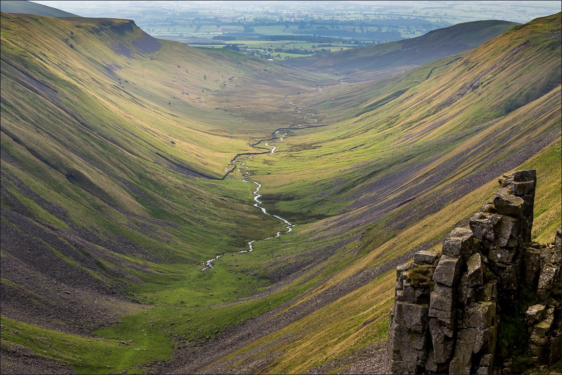
9.0Open moorland suddenly falls away into a vast U-shaped valley, its sides edged by dark crags.
The reveal is the point: a long fellside approach ends where the ground drops into High Cup Gill. The scale, glacial shape and exposed Pennine setting make this worth a dedicated walking day, rather than a quick photograph.
Dramatic · Wild · Big-sky
Find your way
Open mapNear Dufton, North Pennines, Cumbria, England
Opening map…
The experience
Walk up from Dufton for the view into High Cup Gill, giving the approach and return a proper half day. Pause well back from the edge to take in the valley's U-shaped cross-section and crag-lined sides. Experienced navigators can make a longer day through Great Rundale, but that is a materially rougher outing.
Things to do
Walk up for the valley-head reveal
Approach from Dufton towards High Cup Nick, where the open fell gives way to a deep glaciated valley. This is the central experience, not an optional add-on to a roadside stop.
Half day
Read the glacial shape
Look down High Cup Gill from a safe position at the head. Its broad floor and steep sides make the U-shaped profile particularly clear.
Make the longer Great Rundale circuit
Experienced fell walkers can use the documented 11-mile circuit past Dufton Pike and Great Rundale. Its rough, squelchy and sometimes pathless section demands navigation skills; it is not simply a longer version of an easy path.
Full day
Make a day of it
Quick escape · Allow roughly half a day; a supplied walking guide describes an approximately four-hour outing
The essential High Cup reveal
- 01
Start in Dufton with suitable footwear, waterproofs, food, water and a mapped walking route.
- 02
Use the Pennine Way approach towards High Cup Nick rather than treating the viewpoint as a short village stroll.
- 03
Pause at the valley head, well back from the drops, to study the U-shaped valley and photograph its crag-lined sides.
- 04
Return on your planned route with sufficient daylight. Check your chosen route's distance before setting out.
Full Wildland day · Full day; the documented circuit is 11 miles with 1,900 feet of ascent
A full fell day through Great Rundale
- 01
Use the documented Andrews Walks circuit and a suitable map; this outline is not a navigation guide.
- 02
Leave Dufton past the foot of Dufton Pike and climb into Great Rundale.
- 03
Continue towards Great Rundale Tarn only if equipped for rough, boggy and sometimes pathless moorland navigation.
- 04
Reach High Cup Plain and the sudden reveal at High Cup Nick; stop for food away from the cliff edge.
- 05
Follow the documented escarpment-side return to Dufton.
Verified history
The strongest evidenced story here is geological. High Cup Gill is a classic U-shaped glaciated valley, seen most dramatically from its head at High Cup Nick. Grey-blue dolerite crags frame the valley, making its rock structure and glacially shaped form visible in the same view.
Hidden details
The quiet ground before the drop — High Cup Plain is part of the drama: the approach across relatively easy ground gives little sense of the sudden fall into the valley until the view opens.
Look beyond the valley — In clear visibility, the outward views towards the Eden Valley add another layer to the walk. Haze can obscure these even when High Cup itself remains impressive.
When to go
· An early start gives more daylight for the walk and a better chance of finding space in Dufton's small car park.
The source record favours clear spring and autumn days. Visibility and wind matter more than a particular month; longer summer days offer extra flexibility.
Exposed fell terrain, sheer drops and potentially boggy ground. Carry warm and waterproof layers, food, water and reliable navigation. Avoid cliff edges in strong winds or poor visibility. The imported record warns of unreliable phone signal; do not depend on live mobile mapping.
Worth pairing with
Dufton village
Make time for the village green and sandstone buildings at the start or finish. This is a natural complement to the fell walk rather than a separate driving detour.
What to look for
- 01
The abrupt transition from High Cup Plain to the valley head
- 02
the broad U-shaped profile of High Cup Gill
- 03
the crag bands running along its sides
- 04
outward views towards the Eden Valley.
Best time to go
Clear days in spring or autumn; summer offers longer daylight for the approach and return.
Choose clear visibility and light winds over dramatic mist. Start early enough to return in daylight. Late-afternoon light can emphasise the valley's shape, but should not dictate an unsafe late descent.
How long to spend
Half day
Perfect for
Walkers · Photographers
Practical information
Opening & access
Reach on foot from Dufton via the Pennine Way. This is an exposed fell walk, not a roadside viewpoint; carry a map and check the mountain weather forecast.
Check before visiting
Parking
Walking accounts report a small public car park in Dufton, described as free by Away With Maja. It can fill early. Check current charges and restrictions before visiting.
Check before visiting
Toilets
Toilets are reported at the Dufton car park. Check current availability before visiting; do not expect facilities on the fell.
Check before visiting
Food & drink
The imported record reports a small café in Dufton, but gives no name or opening hours. Check before visiting; carry food and water.
Check before visiting
Dogs
The imported record lists dogs as welcome. Check current local restrictions and keep dogs under close control around livestock and cliff edges.
Check before visiting
Accessibility
A substantial uphill walk over exposed, uneven fell terrain. The imported record marks it as not wheelchair accessible. Longer approaches can involve boggy, rough and sometimes pathless ground.
Cost
Check before visiting
Check before visiting
Gallery
Place photographs
Keep exploring
Around High Cup Nick
Within 50 km · approximate straight-line distances