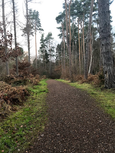
Between Muggleswick and Castleside, County Durham
Derwent Gorge and Muggleswick Woods
route · Woodland walk
Source image
8.1
Wildland
1–2 hours
Time
Check
Cost
Wild
Feel
Why it's Wildland
8.1An out-and-back walk from Muggleswick descends through ancient oak woodland to the River Derwent and the remains of a lead mine, then climbs through the gorge-side woods.
The appeal is the change in atmosphere as the route drops from the village into a steep-sided gorge, with ancient oak woodland, river crossings and visible traces of mining and woodland management. It offers more than a woodland stroll, but steep, wet ground and muddy paths make sturdy footwear important.
Wild · Atmospheric · Ancient-feeling
Find your way
Open mapBetween Muggleswick and Castleside, County Durham
Opening map…
The experience
Take the described out-and-back from Muggleswick: pass the crooked-oak farmhouse, descend by footpath to the River Derwent and lead-mine remains, then cross the river and climb through woodland towards Goldhill Lane before returning. Expect muddy ground and check conditions before attempting the river crossing.
Things to do
Walk from Muggleswick to the River Derwent
Follow the cited out-and-back route from Muggleswick through upland oak woodland to the river and return via Goldhill Lane.
About 1–1.5 hours
Look for the industrial traces in the woods
The reserve source identifies remains of mines and limekilns, as well as evidence of coppice management. Their precise positions are not specified.
Watch for birds along the woodland and river
The reserve describes red kites and buzzards over the canopy, woodland birds including spotted and pied flycatchers and wood warblers, and riverside birds including dippers, kingfishers and goosanders.
Notice the woodland change with the slope
The reserve describes dry acid sessile oak woodland on higher ground, changing to lime-rich ash and wet alder woodland on lower slopes.
Make a day of it
Quick escape · About 1–1.5 hours, based on the cited route description
Quick escape: Muggleswick to the gorge
- 01
Start in Muggleswick and follow the described footpath route towards the River Derwent.
- 02
Pause at the riverside and the remains of the lead mine.
- 03
Cross the river and climb through the woodland to Goldhill Lane, then return by the same route.
- 04
Check river and path conditions before setting out; the paths can be muddy.
Half day · Half day
Make a half day of it: gorge, woods and reserve birdlife
- 01
Walk the Muggleswick out-and-back route to the river and lead-mine remains.
- 02
Allow time to observe the woodland changing from higher-ground oak to lower-slope ash and alder.
- 03
Spend a quiet spell watching the canopy and river; the reserve source lists woodland and riverside birdlife including red kites, buzzards, flycatchers, dippers and kingfishers.
- 04
Finish in Muggleswick or Castleside; no particular café or pub is verified by the supplied sources.
Verified history
The woods and gorge were declared a National Nature Reserve in 1992. The reserve source records 18th- and 19th-century activity associated mainly with mining and the mineral industry, including remains of mines and limekilns, alongside evidence of coppice management.
Hidden details
Mining and limekiln remains — Look out for the recorded remains of mines and limekilns in the reserve; the supplied source does not give precise locations.
A woodland of changing conditions — The reserve’s higher ground supports dry acid sessile oak woodland, while lower slopes include lime-rich ash and wet alder woodland.
When to go
March · April · May · No specific time of day is established by the supplied sources; check weather and path conditions before setting out.
The reserve identifies spring as the best time for flora and notes breeding woodland birds. The cited route also reports bluebells and wild garlic in spring.
Paths can be muddy. The reserve warns of steep, wet and slippery areas away from footpaths and a risk of falling trees or branches in high winds. Check conditions before attempting the river crossing.
The route
- ascent
- 423 ft elevation gain
- stiles
- Not established for this route.
- surface
- Footpaths and woodland paths; muddy underfoot conditions are reported.
- distance
- 2.9 miles
- duration
- 1–1.5 hours
- difficulty
- Easy according to the cited route listing; expect muddy paths and a river crossing.
- waymarking
- Not established.
- route shape
- Out and back
- start point
- Muggleswick; the cited route continues past the crooked-oak farmhouse.
- parking start
- The route listing starts in Muggleswick. Reserve information describes small lay-bys along the Castleside–Muggleswick road and better parking at nearby Derwent Reservoir; exact start-point parking is not confirmed.
- shorter alternative
- No shorter alternative is verified in the supplied sources.
- Ancient oak woodland
- River Derwent and gorge
- Remains of a lead mine
- Spring bluebells and wild garlic
- Woodland and riverside birdlife
Worth pairing with
Derwent Reservoir
The reserve source identifies better parking facilities at nearby Derwent Reservoir. No further visitor activity or facility details are established here.
What to look for
- 01
Look for the contrast between drier oak woodland on higher ground and wetter ash and alder woodland lower down
- 02
notice the remains of mining, limekilns and coppice management. In spring, look for bluebells and wild garlic, and listen for woodland and riverside birds.
The story
Mining and mineral industry; lead-mine remains, limekilns and evidence of coppice management.
Best time to go
Spring, when woodland flowers including bluebells and wild garlic are reported, and woodland birds are active.
Spring is the strongest season for woodland flowers and breeding birds. Choose a calm day; the reserve advises caution around falling trees and branches in high winds.
How long to spend
1–2 hours
Perfect for
Walkers · Wildlife lovers · Photographers
Route at a glance
Duration
1–2 hours
Terrain
Woodland, Valley
Parking / start
The reserve source describes several small lay-bys on the Castleside–Muggleswick road, with space for up to two cars, and better parking at nearby Derwent Reservoir. Check current parking arrangements before travel.
Practical information
Opening & access
Footpath access is described from Muggleswick, Castleside and Edmundbyers. The reserve also has several small lay-bys along the Castleside–Muggleswick road; access and conditions should be checked before setting out.
Check before visiting
Parking
The reserve source describes several small lay-bys on the Castleside–Muggleswick road, with space for up to two cars, and better parking at nearby Derwent Reservoir. Check current parking arrangements before travel.
Check before visiting
Toilets
Check before visiting
Check before visiting
Food & drink
Check before visiting
Check before visiting
Dogs
Check current reserve guidance and signage before visiting.
Check before visiting
Accessibility
Not established as accessible. The route includes a descent to the river and woodland slopes; steep, wet and slippery areas are reported away from footpaths.
Cost
Check before visiting
Check before visiting
Water
River
Gallery
Place photographsKeep exploring
Around Derwent Gorge and Muggleswick Woods
Within 50 km · approximate straight-line distances