Gidleigh Common, near Gidleigh, Dartmoor, Devon
Scorhill Stone Circle
Prehistoric
Source image
6.2
Wildland
1–2 hours
Time
Check
Cost
Atmospheric
Feel
Why it's Wildland
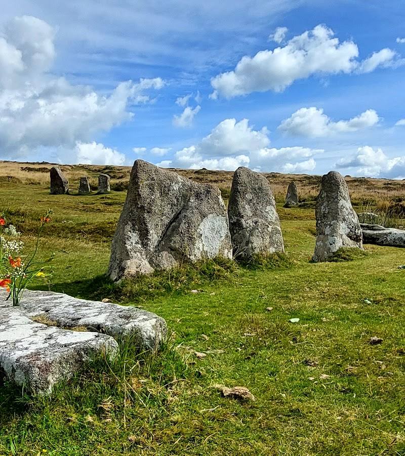
6.2On open Dartmoor, Scorhill’s ring of standing and fallen stones is a striking prehistoric landmark. A supplied walking guide describes it as one of Dartmoor’s finest stone circles, with two cart tracks passing through the ring.
Scorhill earns its place for the way a substantial prehistoric monument sits within open Dartmoor moorland, with a longer walking route linking the circle to other landscape and heritage features. The approach and practical access details need checking before setting out.
Atmospheric · Ancient-feeling · Wild
Find your way
Open mapGidleigh Common, near Gidleigh, Dartmoor, Devon
Opening map…
Know this place a little better?
The experience
Visit the circle on foot and take time to read the ring of standing and fallen stones against the open moor. For a more substantial outing, a supplied Dartmoor walk links Scorhill with Round Pound, the North Teign and the Tolmen Stone. Confirm access, route conditions and parking before setting out.
Things to do
Read the stone circle
Walk around the ring and notice the combination of upright and fallen stones. The supplied walking guide describes two cart tracks running through the circle and a fallen stone showing signs of an attempted split.
Extend the visit along the Scorhill and Teignhead walk
The supplied route description links Scorhill with Round Pound, open moorland, the North Teign and the Tolmen Stone. Check the full route, access and conditions before setting out.
Make a day of it
Quick escape · Check before visiting
A short visit to the stone circle
- 01
Reach the circle on foot across the open moorland; confirm the approach and access before setting out.
- 02
Walk around the ring and look for the standing and fallen stones and the tracks crossing the circle.
Half day · Check before visiting
Scorhill and the surrounding moorland heritage
- 01
Use the supplied Scorhill and Teignhead walk as a basis for a longer outing, checking the route and parking details before departure.
- 02
Visit Round Pound and follow the described moorland route towards Scorhill.
- 03
Continue to the North Teign and Tolmen Stone only if following the full walk and conditions allow.
Verified history
A supplied Dartmoor walking guide describes Scorhill as a stone circle on the moor, with 34 stones remaining from an original 65–70 and 25 still standing. It also notes two cart tracks crossing the ring and a fallen stone with signs of an attempted split using the feather-and-tare method. A separate visitor listing describes the circle as Bronze Age and gives an approximate diameter of 27 metres; that listing’s description is explicitly identified as AI-generated, so these particulars should be treated cautiously.
Folklore & legend
No Scorhill-specific legend is sufficiently supported for inclusion. The supplied walking guide recounts healing beliefs associated with the nearby Tolmen Stone; these are presented as reported traditional beliefs, not fact.
Hidden details
The marks on a fallen stone — The supplied walking guide points out signs of an attempted stone split using the feather-and-tare method. Look closely at the fallen stone described in the guide; its precise position is not specified.
When to go
· No time of day is verified. Check weather and visibility before a moorland visit.
The supplied sources do not establish a best season for visiting.
Conditions and visibility on open moorland can affect the longer walk. Its guide says a map and compass are essential in poor visibility, particularly on the Teignhead section.
Worth pairing with
Round Pound
A prehistoric enclosure included in the supplied Scorhill and Teignhead walk; the guide describes its central hut circle and substantial outer walls.
Tolmen Stone
A large river boulder with a hole through it, described by the supplied walk guide as a nearby stop on the longer route.
What to look for
Notice the standing and fallen stones, the two cart tracks crossing the ring and the fallen stone described in the walking guide as showing signs of an attempted split using the feather-and-tare method. A visitor source describes lichen on the stones, but this detail is less authoritative.
The story
Prehistoric archaeology; stone-circle landscape
Best time to go
Check conditions before travelling; no specific seasonal recommendation is verified.
No best time or season is verified in the supplied sources. Check weather and visibility before a moorland visit; the supplied walk guide warns that a map and compass are essential in poor visibility on its longer route.
How long to spend
1–2 hours
Perfect for
Walkers · History lovers · Photographers
Before you go
Address
Listed hours
- Monday: Open 24 hours
- Tuesday: Open 24 hours
- Wednesday: Open 24 hours
- Thursday: Open 24 hours
- Friday: Open 24 hours
- Saturday: Open 24 hours
- Sunday: Open 24 hours
Check before visiting.
Google rating
Practical information
Opening & access
The circle is reached on foot across open moorland. Access rights, the best current approach and parking arrangements are not confirmed in the supplied sources; check before visiting. The accepted map pin marks the place, not an entrance or parking area. Access arrangements are unconfirmed. Check before visiting; do not enter private land or restricted structures.
Check before visiting
Parking
Check before visiting. A supplied walk guide describes parking at Batworthy Corner for its longer route; it does not verify parking for a direct visit to the circle.
Check before visiting
Toilets
Check before visiting
Check before visiting
Food & drink
Check before visiting
Check before visiting
Dogs
Check before visiting
Check before visiting
Accessibility
The circle is reached on foot across open moorland. The supplied walk description mentions stiles; wheelchair or pushchair access is not verified. Check route conditions and access before visiting.
Check before visiting
Cost
Check before visiting
Check before visiting
Gallery
Place photographsKeep exploring
Around Scorhill Stone Circle
Within 50 km · approximate straight-line distances