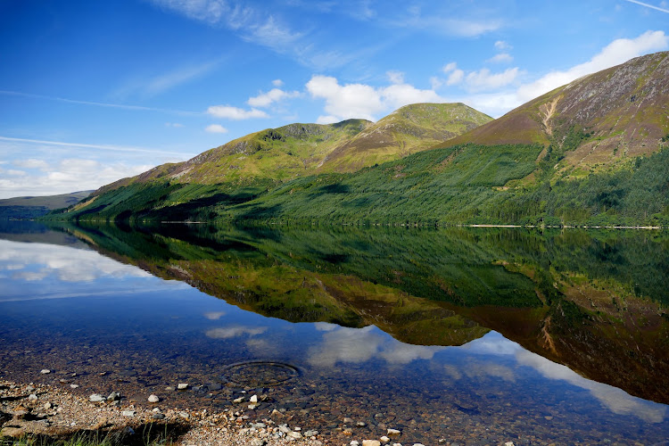
Glen Shiel, Scottish Highlands
Loch Cluanie
Reservoir
Source image
6.2
Wildland
Under 1 hour
Time
Check
Cost
Dramatic
Feel
Why it's Wildland
6.2A Highland loch reshaped by hydroelectric engineering: Cluanie Dam was built in 1955, and drought once revealed a drovers’ bridge submerged beneath the reservoir.
Loch Cluanie earns its place through the contrast of a large Highland waterscape and the human history beneath it: a 1950s hydroelectric project flooded an old route, while the A87 and the hills give visitors striking views across the water. It is best treated as a scenic stop, not as a destination with verified waterside facilities or activities.
Dramatic · Wild · Remote
Find your way
Open mapGlen Shiel, Scottish Highlands
Opening map…
Know this place a little better?
The experience
Loch Cluanie is a Highland reservoir best approached as a short scenic and historical stop. Take in the water and mountain setting from a suitable roadside viewpoint, and consider the landscape’s layers: the dam, the A87’s older military-road history, and the route submerged beneath the water. Do not assume that swimming, paddling, or unrestricted shoreline access is permitted.
Things to do
Take in the Highland reservoir setting
Pause at a safe, permitted viewpoint to look across Loch Cluanie towards the surrounding hills. The A87 runs along the northern shore; do not stop where it would be unsafe or prohibited.
Short stop
Trace the loch’s engineering story
The Cluanie Dam was built in 1955 as part of a hydroelectric project. A drought in 2012 exposed a drovers’ bridge that had been submerged since the reservoir was created; the source does not establish whether it can be seen today.
Follow the older road story
The supplied history says the modern A87 follows the northern edge of the loch and, for much of the way, follows the route of an 18th-century military road associated with General Wade.
Make a day of it
Quick escape · Under 1 hour
Quick lochside look
- 01
Use a suitable, currently available stopping place; a parking area beside the Cluanie Inn is reported, but check access and restrictions first.
- 02
Take in the loch and surrounding hills from a safe, permitted viewpoint.
- 03
Notice the dam-era story of the submerged drovers’ bridge; do not expect it to be visible.
Verified history
Cluanie Dam was built across the River Cluanie in 1955 as part of a North of Scotland Hydro-Electric Board project. The supplied source describes the dam as 675 metres long and 40 metres high. The A87 runs along the loch’s northern edge and follows the route of an 18th-century military road for much of the way. In 2012, summer drought exposed a drovers’ bridge that had been submerged since the reservoir was created.
Hidden details
The drowned drovers’ bridge — A drovers’ bridge, part of an older route, was exposed when drought lowered the water in 2012. The supplied source does not say whether it is visible now.
The older road beneath the modern route — The A87’s route along the northern edge of the loch is described as following an 18th-century military road for much of the way.
When to go
· Not established by the supplied sources.
The supplied sources do not identify seasonal wildlife, scenery, or access patterns for visitors. Check weather and road conditions before travelling.
Check current Highland weather and road conditions before setting out. The supplied sources do not provide site-specific weather or safety guidance.
Worth pairing with
Cluanie Inn
At the western end of the loch. A supplied source reports a nearby parking area and describes the inn as a starting point for hill walks; check current facilities, access, and conditions before relying on them.
What to look for
- 01
Look across the loch towards the surrounding hills and consider how much of the landscape was changed by the 1955 dam. The drovers’ bridge mentioned in the history was exposed during drought in 2012
- 02
its visibility now is not established.
The story
Hydroelectric engineering; General Wade’s military road; a submerged drovers’ bridge.
Best time to go
No specific season is established by the supplied sources; check conditions before travelling.
The supplied sources do not identify a best time of day or season. Check weather and road conditions before travelling.
How long to spend
Under 1 hour
Perfect for
Photographers · History lovers · Walkers
Practical information
Opening & access
The A87 follows the northern shore. A source reports a parking area beside the Cluanie Inn at the western end, with access to the loch; check current parking arrangements and access before setting out.
Check before visiting
Parking
A parking area beside the Cluanie Inn is reported by one supplied source. Confirm availability and any restrictions before visiting.
Toilets
Check before visiting
Check before visiting
Food & drink
The Cluanie Inn is at the western end of the loch; check current food service and opening details before visiting.
Check before visiting
Dogs
Check before visiting
Check before visiting
Accessibility
Check before visiting; accessible paths and facilities are not established by the supplied sources.
Check before visiting
Cost
Check before visiting
Check before visiting
Water
Reservoir
Gallery
Place photographsKeep exploring
Around Loch Cluanie
Within 50 km · approximate straight-line distances