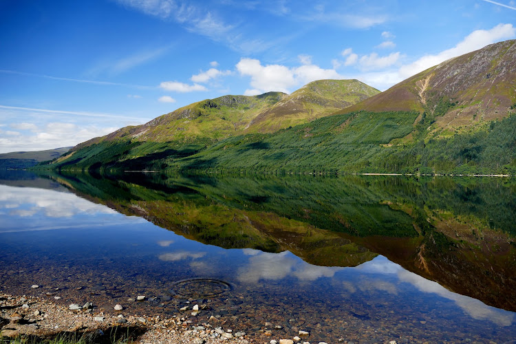
Glen Roy, Lochaber, Scottish Highlands
Glen Roy National Nature Reserve
Mixed-habitat reserve
Place photograph
8.2
Wildland
Half day
Time
Check
Cost
Dramatic
Feel
Why it's Wildland
8.2Glen Roy’s long, level ‘Parallel Roads’ are traces of ice-dammed lakes that formed and drained at the end of the last Ice Age.
This is a landscape where the evidence of ancient ice is written across the hillsides. The Parallel Roads, river terraces and landslips make the geology the reason to come, while the mountain setting and native woodland add a strong sense of place.
Dramatic · Wild · Remote
Find your way
Open mapGlen Roy, Lochaber, Scottish Highlands
Opening map…
Know this place a little better?
The experience
Come for the Parallel Roads and take time to read them in the wider landscape: look for the level terraces, river fans and landslips described by NatureScot. This is a rugged, remote Highland reserve, so plan conservatively and check access and conditions before travelling.
Things to do
Spot the Parallel Roads
Look for the conspicuous level lines across the hillsides. NatureScot explains them as former shorelines of ice-dammed lakes formed and drained at the end of the last Ice Age.
Look for other glacial landforms
Beyond the headline terraces, look for river fans, terraces and landslips in the wider valley landscape.
Watch for Highland wildlife
NatureScot says visitors may see red deer, ravens and buzzards, and occasionally a golden eagle.
Find spring flowers in the woodland
Look for pockets of native birch and oak woodland along the river and on the slopes; NatureScot notes that these are rich in spring flowers.
Make a day of it
Quick escape · Allow 1–2 hours; this is a suggested visit length, not a sourced route duration.
Read the Parallel Roads
- 01
Check current access, road and weather conditions before travelling.
- 02
From an appropriate visitor viewpoint or walking area, look across the hillsides for the long, level Parallel Roads.
- 03
Use the landscape to identify the other glacial features NatureScot describes: river terraces, river fans and landslips.
Verified history
At the end of the last Ice Age, ice-dammed lakes formed and drained in Glen Roy. Their former water levels left the parallel lines now visible on the hillsides. NatureScot also identifies river fans, terraces and landslips as part of the reserve’s glacial landscape. For centuries, geologists debated the origin of the lines before the ice-dammed-lake explanation resolved the puzzle.
Hidden details
The ‘roads’ are former lake shorelines — Despite their name, the Parallel Roads are geological terraces: traces of successive levels of ice-dammed lakes, not built roads.
Look beyond the famous lines — NatureScot also points to river fans and landslips among the reserve’s glacial landforms.
When to go
May · June · July · August · September · No specific time of day is supported by the supplied sources.
NatureScot highlights spring and summer for woodland flowers; the source row recommends May to September for generally milder conditions. Neither source establishes precise peak dates.
Highland weather can change quickly. The source row warns that snow and ice can make winter visits challenging. Check the forecast, road conditions and current access before travelling.
What to look for
- 01
The long, level Parallel Roads on the hillsides
- 02
river terraces, river fans and landslips
- 03
pockets of native birch and oak woodland and their spring flowers. Red deer, ravens and buzzards may be seen
- 04
golden eagles are occasional.
The story
Ice Age geology and glacial landforms
Best time to go
Spring and summer for woodland flowers; check conditions before travelling in winter.
NatureScot highlights spring and summer for wild flowers in the woodland. The source row recommends May to September, but exact conditions vary; check the forecast and access before setting out.
How long to spend
Half day
Perfect for
Walkers · Photographers · Wildlife lovers · History lovers
Practical information
Opening & access
Visitor walks and a car park are mentioned in the supplied sources. The approach includes a narrow, single-track road with passing places; check current access and conditions before setting out.
Check before visiting
Parking
A visitor car park is mentioned by a supplied visitor source. Check current access and parking arrangements before travelling.
Check before visiting
Toilets
Check before visiting
Check before visiting
Food & drink
No on-site café or shops are reported in the source row; bring supplies and check locally.
Check before visiting
Dogs
The source row identifies the reserve as dog friendly; check current reserve guidance and signage.
Check before visiting
Accessibility
The source row describes rugged terrain and says the reserve is not wheelchair accessible. Check current conditions before visiting.
Check before visiting
Cost
Check before visiting
Check before visiting
Water
River
Gallery
Place photographsKeep exploring
Around Glen Roy National Nature Reserve
Within 50 km · approximate straight-line distances