Hope Valley, Derbyshire, Peak District
Ladybower Reservoir
Reservoir
Place photograph
8.0
Wildland
1–2 hours to a full day, depending on route
Time
Check
Cost
Dramatic
Feel
Why it's Wildland
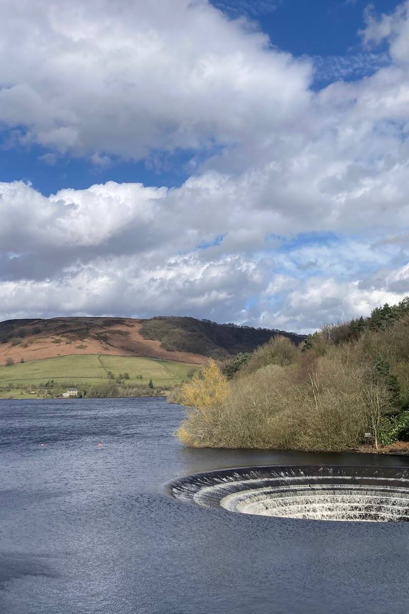
8.0Ladybower is the lower of three linked reservoirs in the Upper Derwent Valley. Its famous bell-mouth spillways—often called the plugholes—sit in a landscape also marked by the flooded villages of Derwent and Ashopton.
The appeal is more than a broad stretch of water: Ladybower brings together a striking reservoir landscape, the distinctive plugholes and the submerged history of two villages. Nearby trails offer ways to experience the valley on foot or by bike.
Dramatic · Big-sky · Wild
Find your way
Open mapHope Valley, Derbyshire, Peak District
Opening map…
Know this place a little better?
The experience
Choose a short waterside visit or make more time for a walk or cycle in the surrounding valley. The supplied sources also describe a longer circular walk from Bamford, but confirm the route and conditions before setting out.
Things to do
Walk beside the reservoir
Explore a suitable waterside section of the walking trails. The supplied sources mention routes ranging from easy walks to more challenging hikes; check route conditions and access before setting out.
See the plugholes
Look for Ladybower’s two circular bell-mouth spillways, a distinctive feature of the reservoir. Confirm the best viewing point and current access before visiting.
Cycle in the reservoir landscape
Cycling is described among the ways to explore the area. The supplied sources do not specify a route, distance or hire arrangements, so check these before planning a ride.
Make a day of it
Quick escape · Approximately 1–2 hours; confirm the chosen walk locally.
Quick reservoir escape
- 01
Choose a current, suitable waterside walking section and check access and conditions before setting out.
- 02
Look for views of the reservoir and its surrounding hills.
- 03
If visible from your chosen route, seek out the circular plugholes.
- 04
Return by the same route unless you have confirmed a suitable circuit.
Half day · A supplied walk account describes a 2–2.5-hour journey; allow extra time and check its route details before setting off.
Make a half day of it: follow a longer reservoir walk
- 01
Use a confirmed route to explore more of the reservoir landscape on foot.
- 02
Include the dam and plugholes if the route and current access allow.
- 03
Pause at viewpoints over the water and surrounding hills.
- 04
Check whether the Fairholmes visitor centre is open before making it part of your plan.
Verified history
Ladybower was built between 1935 and 1943 and opened in 1945 by King George VI, according to the supplied attraction source. It is the lower of three linked reservoirs. The villages of Derwent and Ashopton were flooded to create the reservoir; their remains may reappear when water levels fall.
Hidden details
The villages beneath the water — The remains of Derwent and Ashopton may reappear when reservoir levels fall. The supplied source does not establish when this happens or whether remains are currently visible.
The circular spillways — Ladybower’s two bell-mouth spillways are known locally as plugholes and make a distinctive feature to look for around the reservoir.
When to go
· No particular time of day is established by the supplied sources; check weather and visibility before travelling.
The supplied sources do not establish a best season.
Check the forecast and current route conditions before setting out, particularly for longer walks.
The route
- Ladybower Reservoir
- The dam and circular plugholes
- Views across the surrounding hills
Worth pairing with
Fairholmes visitor centre
The supplied attraction source mentions Fairholmes visitor centre as a possible stop. Check its current opening and facilities before planning around it.
Bamford circular walk
A supplied route page describes a circular walk starting in Bamford that combines reservoir views, riverside paths, historic railway trails and the dam. Verify the full route details and conditions before relying on it.
What to look for
The reservoir’s two circular bell-mouth spillways, known locally as plugholes. When water levels fall, remains of the flooded villages of Derwent and Ashopton may reappear.
The story
Flooded villages; reservoir construction
Best time to go
Check current conditions before travelling; the supplied sources do not establish a best season.
No specific best time is verified in the supplied sources. Check weather, visibility and current route conditions before travelling.
How long to spend
1–2 hours to a full day, depending on route
Perfect for
Walkers · Cyclists · Photographers · History lovers
Before you go
Address
Google rating
Practical information
Opening & access
A reservoir destination with waterside walking and cycling routes described by the supplied sources. Check current access, route conditions and facilities before visiting.
Check before visiting
Parking
Check before visiting; parking locations and availability are not established by the supplied sources.
Check before visiting
Toilets
Check before visiting
Check before visiting
Food & drink
Check before visiting
Check before visiting
Dogs
Check before visiting
Check before visiting
Accessibility
Check before visiting. The supplied sources do not establish accessible routes or facilities.
Check before visiting
Cost
Check before visiting
Check before visiting
Water
Reservoir
Gallery
Place photographs
Keep exploring
Around Ladybower Reservoir
Within 50 km · approximate straight-line distances