South-east England, stretching from Winchester to Eastbourne
South Downs National Park
Rolling hills
Source image
7.8
Wildland
Half day, Full day, Multi-day
Time
Check
Cost
Big-sky
Feel
Why it's Wildland
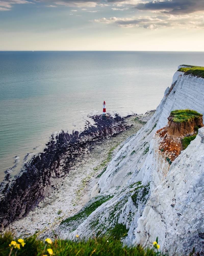
7.8A long chalk ridgeline runs through a landscape of rolling downs and valleys, meeting the sea at the stark, rippling cliffs of the Seven Sisters.
The South Downs earns its place for the way open chalk hills, deep valleys and an internationally recognised dark-sky landscape meet a coast of immense white cliffs. It is a region to explore through specific walks and places, not a single attraction with one entrance.
Big-sky · Dramatic · Wild
Find your way
Open mapSouth-east England, stretching from Winchester to Eastbourne
Opening map…
Know this place a little better?
The experience
Treat the South Downs as a landscape to explore from a chosen starting point. Pick a section of the South Downs Way or another verified local route, and check its access and practical details before setting out. The supplied evidence supports the park’s major landscapes and broad activities, but not a specific itinerary from the imported map pin.
Things to do
Walk a section of the South Downs Way
The National Trail runs for 100 miles from Winchester to Eastbourne, entirely within the National Park. Choose a section suited to your time and check its route and access details before setting off.
See the Seven Sisters chalk cliffs
Take in the distinctive sequence of chalk peaks and dips, described by the National Park Authority as remnants of dry valleys gradually eroded by the sea. Check local route and access details first.
Go stargazing
The National Park Authority provides a beginner’s guide to stargazing. Choose a clear night and check the guidance and local access arrangements before visiting a viewing location.
Make a day of it
Quick escape · Allow 1–2 hours, depending on the chosen location and route.
A short South Downs escape
- 01
Choose a verified local route or a named special place before travelling; the supplied map pin is not a trailhead.
- 02
Walk a manageable section and pause for the views across the downs or towards the coast.
- 03
Check local access, conditions and facilities before setting out.
Half day · Half day
Make a half day of it
- 01
Choose one named place within the park, such as the Seven Sisters Country Park, and check its current access information.
- 02
Explore a suitable section of the South Downs Way or another locally verified route.
- 03
Allow time to take in the chalk scenery; verify food, toilets and transport for your chosen location before travelling.
Verified history
The supplied official material describes the South Downs Way as a 100-mile National Trail from Winchester to Eastbourne and says the National Park’s ridgeline has been walked by people for as far back as can be discovered. It also describes Arundel Castle as first established in 1067. The source material does not establish a more detailed history for the supplied map pin.
Hidden details
The Seven Sisters are eroding dry valleys — The official park account identifies the cliffs’ repeating peaks and dips as remnants of dry valleys that are gradually being worn away by the sea.
When to go
April · May · June · July · August · September · Daylight for downland and coastal views; a clear night for stargazing.
Longer daylight makes walking and exploring easier in spring and summer. Clear skies, rather than a particular month, are the key condition for stargazing.
Conditions vary across this extensive landscape. Check the forecast and local route information before setting out.
Worth pairing with
Arundel
The National Park Authority identifies Arundel as a historic market town in the Arun valley, with trails, pubs and cafés. It may pair well with a visit in the western part of the park; check opening and travel details.
Seven Sisters Country Park
A named National Park special place, with access to the chalk cliffs and coastal landscape. Check current local visitor information before planning a visit.
What to look for
At the Seven Sisters, notice the repeated folds of the chalk cliffs: the official National Park account describes them as remnants of dry valleys, gradually eroded by the sea. Along the South Downs Way, look for the contrast between the ridgeline and the valleys below.
The story
Historic landscapes and the South Downs Way
Best time to go
Spring to autumn for walking and longer days; choose a clear, calm night for stargazing.
Choose a clear day for long views across the downs or towards the sea. For stargazing, look for a clear night and check local guidance before setting out.
How long to spend
Half day, Full day, Multi-day
Perfect for
Walkers · Cyclists · Photographers · Wildlife lovers
Before you go
Practical information
Opening & access
The National Park Authority describes day visits to places within the park and promotes walking routes. The park is extensive, so check access, route conditions and any local restrictions for your chosen starting point.
Check before visiting
Parking
Parking depends on the chosen location; check before visiting.
Check before visiting
Toilets
Check before visiting; facilities vary by location.
Check before visiting
Food & drink
Check before visiting; food options vary by location.
Check before visiting
Dogs
Check before visiting and follow local signs and countryside guidance.
Check before visiting
Accessibility
The park’s Miles Without Stiles information may help identify more accessible routes. Check the details for the specific route and facilities before travelling.
Check before visiting
Cost
Check before visiting
Check before visiting
Water
Sea
Gallery
Place photographsKeep exploring
Around South Downs National Park
Within 50 km · approximate straight-line distances